Short answer
Iki Airport is a compact island-airport stop for travelers who enjoy comparing air and sea access. Use the 1,200m runway context, the Nagasaki air route, Hakata and Karatsu ferry or jetfoil choices, port selection, rental-car, bus, taxi, and island-weather checks to build a practical transport-fan day on Iki Island.
Last checked: August 21, 2026. Flight operations, airline schedules, airport services, ferry and jetfoil sailings, port operations, bus timetables, taxi availability, rental-car inventory, bicycle or scooter availability, accessibility support, weather, sea conditions, and typhoon disruption can change. Always confirm current details on official airport, airline, ferry, city, tourism, transport, and weather pages before travel.
Why Iki works for transport fans
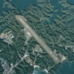
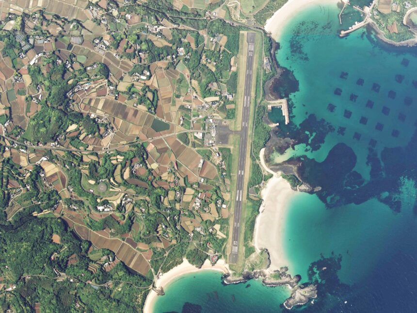
Nagasaki Prefecture describes Iki Airport as located in Ishida on the eastern side of Iki Island, between Fukuoka Prefecture and Tsushima. The airport opened in July 1966 and has one runway, 1,200m long and 30m wide. The same official page says Oriental Air Bridge operates between Iki and Nagasaki / Omura Airport, while charter, private, emergency, police, Self-Defense Force, aviation-school training aircraft, and helicopters also use the airport.
That makes Iki different from big observation-deck airports. The value is the transport system: a short island runway, a Nagasaki air link, several sea routes, multiple arrival ports, and a compact island where your choice of car, bus, taxi, bicycle, or scooter changes the day. Keep the aviation side respectful. Use public terminal spaces, legal roads, sidewalks, ports, and properly used parking areas. Avoid fence-line spotting, service roads, private land, drone use, and anything that interferes with airport operations or local traffic.
Start with the airport as a gateway
For an aviation-focused visit, treat Iki Airport as the arrival and orientation point rather than a full-day attraction. Confirm the current Oriental Air Bridge schedule, airport services, local transport pickup, and weather before you travel. Because the route is short and island weather matters, build in enough flexibility for delays, cancellations, or a switch between air and sea planning.
The airport’s official prefectural page is most useful for stable airport context: location, runway size, opening history, and operational role. For traveler movement, combine that with Iki Tourism’s official access and transport pages, then confirm the final details with the airline, ferry operator, rental-car company, bus operator, taxi company, or accommodation.
Compare the airport with Iki’s ports
Iki Tourism’s official access page lists Nagasaki Airport to Iki Airport by Oriental Air Bridge, and it also shows sea routes involving Hakata Port, Karatsu East Port, Izuhara Port, Gonoura Port, Ashibe Port, and Indoji Port. That mix is the real planning hook. You can arrive by air and leave by sea, or compare the airport with the port that best matches your lodging and sightseeing area.
The port choice matters. The official tourism page notes that sailing time and arrival port can differ, so travelers should choose a boat according to where they will stay or go on the island. Do not assume every ferry or jetfoil uses the same port. Before booking, check whether your route uses Gonoura, Ashibe, or Indoji, and match that with bus, taxi, rental-car pickup, baggage, and return movement.
Choose local movement before landing
Iki Tourism’s transport page lists plane and ship access, rental cars, taxis, buses, rental bicycles, wheelchair support, and other practical movement options. Its accessible-travel feature also points to airport and port support, route buses, taxis, rental cars, and wheelchair-related help. These are useful options, but availability can change and some services require advance arrangement.
A rental car is often the easiest way to connect the airport, ports, beaches, food stops, shrines, viewpoints, and accommodation. A bus or taxi plan can work when it is based on current timetables, dispatch realities, and return movement. Bicycle, e-bike, scooter, or beach add-ons should be planned around weather, wind, heat, road conditions, daylight, and baggage.
Add one island branch
For a first airport-area day, choose one branch. A transport branch can compare Iki Airport with Gonoura, Ashibe, or Indoji port movement. A food branch can focus on the area that matches your arrival route. A scenery branch can use a beach, viewpoint, or coastal route. A cultural branch can include shrines or historic sites, but it should respect local etiquette, photography rules, parking, and quiet spaces.
Iki is close enough to Fukuoka by sea that it can feel easy, but the trip still depends on weather and port logistics. A calm plan with one branch, confirmed transport, and a protected return window will feel better than a checklist that ignores ferry times, road distance, luggage, or sudden wind.
Simple first-time plan
| Step | What to do | Why it works |
|---|---|---|
| 1 | Check flight status, ORC schedule, airport services, ferry or jetfoil status, arrival port, bus timetable, taxi availability, rental-car reservation, and weather | Iki plans depend on air, sea, road, and weather conditions |
| 2 | Use Iki Airport’s public terminal and 1,200m runway context as the aviation anchor | The airport is small, but its air-sea comparison is interesting |
| 3 | Choose whether your next movement should be airport-based, Gonoura-based, Ashibe-based, or Indoji-based | Port choice affects the whole day |
| 4 | Add one branch: port logistics, food, beach, shrine, viewpoint, bicycle, scooter, or compact coastal route | One branch keeps the plan realistic |
| 5 | Leave buffers before flight departure, ferry sailing, rental return, bus connection, sunset, and bad-weather changes | Island travel rewards spare time |
Where this fits in the transport hub
Use this as the Iki branch of the Japan Transport Fan Travel Guide. It pairs naturally with Nagasaki, Fukue, Tsushima, Tanegashima, Yakushima, Amami, Kikai, Tokunoshima, Okinoerabu, Yoron, and other island-airport guides, but Iki stands out because airport planning and port choice are inseparable.
Photo credit
Featured image: Iki airfield aerial photograph, credited to the Ministry of Land, Infrastructure, Transport and Tourism, made based on National Land Image Information (Color Aerial Photographs), via Wikimedia Commons, licensed under CC BY 4.0. Cropping or resizing may be applied for site display. The image is used in editorial transport-travel-guide context and does not imply endorsement by MLIT, GSI, Nagasaki Prefecture, Iki Airport, airport operators, Oriental Air Bridge, ferry operators, tourism organizations, Wikimedia, or the uploader.
Sources
- Nagasaki Prefecture: Iki Airport overview
- Iki Tourism official: access to Iki Island
- Iki Tourism official: useful transport on Iki
- Iki Tourism official: accessible travel support
- Wikimedia Commons image file and license record
Editorial disclosure: This is an independent planning guide. It is not affiliated with Nagasaki Prefecture, Iki Airport, Oriental Air Bridge, ferry operators, bus operators, taxi operators, rental-car companies, Iki Tourism, Iki City, MLIT, GSI, Wikimedia, or the image uploader.