Use regional airports only when they improve the trip
Short answer: Japan’s regional airports can be excellent aviation stops, but not every airport deserves a separate detour. Choose one when it adds a good observation deck, a local-food break, unusual access, a clear nearby destination, or a route you already need. Use official airport pages for current deck access, transport, restaurants, and notices before going.
Last checked: August 27, 2026. Airport facilities, observation decks, public access, restaurants, bus routes, taxi rules, parking, events, and flight operations can change. Confirm current details with official airport and operator sources before travel.
What makes a regional airport worth time?
MLIT’s airport list, current as of April 1, 2026, shows that Japan has many airport types beyond the biggest gateways. Some are national-government airports, some are local management airports, and some are joint-use airports. For travelers, the useful question is not the legal category. It is whether the airport solves a real travel problem or adds a memorable aviation moment.
A good regional airport stop usually has at least one of these: an official observation deck, easy public transport to the city, a strong local-food or souvenir floor, an unusual runway or coastal setting, or a nearby destination you already want to visit.
Regional airport map by travel use
| Airport | Best trip fit | Check first |
|---|---|---|
| Matsuyama | Shikoku city gateway with airport-deck and local-food potential. | Official deck, access, shops, and city bus timing. |
| Toyama | Compact Hokuriku airport for mountain-side regional travel. | Facilities, access, weather, and city transfer. |
| Komatsu | Hokuriku gateway for Kanazawa / Kaga with aviation interest. | Observation space, bus access, and joint-use context. |
| Okayama | Chugoku gateway that can pair with Okayama or Kurashiki. | Bus access, terminal facilities, and flight timing. |
| Yonago | Sanin gateway for Tottori / Shimane-side itineraries. | Ground access, terminal layout, and local route status. |
| Hiroshima | Major regional airport with deck and inland access planning. | Observation deck, limousine bus, and city travel time. |
| Izumo | Shimane gateway for shrine and Sanin travel. | Deck, access, and destination-side transport. |
| Takamatsu | Shikoku / Setouchi route base with compact terminal planning. | Deck, bus access, art-island connections, and food options. |
| Kochi Ryoma | Kochi gateway where airport time can support a city or coast route. | Facility, access, and bus or rental-car timing. |
| Tokushima | Shikoku airport with city and Naruto-side planning potential. | Deck, access, taxi, and bus pages. |
| Kitakyushu | Airport-island setting, later flight pattern potential, and local facilities. | Deck, transport, late / early flight handling, and notices. |
| Oita | Coastal airport with observation deck, food, and Beppu / Yufuin access logic. | Deck, bus, taxi, car, and facility pages. |
| Saga | Quiet Kyushu airport that can work when it matches the route. | Space park, access, route frequency, and local bus options. |
| Nagasaki | Island-airport setting and city / ferry access planning. | Deck, bus, ferry, and access pages. |
| Kumamoto | Rebuilt terminal and Aso / Kumamoto access logic. | Observation space, access, and terminal notices. |
| Miyazaki | Rail-linked regional airport for coast and city routes. | Deck, train, bus, taxi, and weather. |
| Kagoshima | Southern Kyushu gateway with deck, displays, and hot-spring-region access. | View deck, bus, taxi, car, and facility notices. |
| Nanki Shirahama | Small Kii Peninsula airport that makes sense only when Shirahama / Kumano timing fits. | Flight status, access, rental car, and local tourism links. |
Do not collect airports like stamps
The weak version of an aviation trip is adding every airport because it has a deck. The better version is choosing one airport that improves the day. For example, Oita can be useful if you are already heading to Beppu or Yufuin. Hiroshima makes sense if the airport transfer is part of a Chugoku itinerary. Kagoshima can support a southern Kyushu plan. Nanki Shirahama is only useful when it actually fits the Kii Peninsula route.
If the airport creates more transfers than enjoyment, skip it. Use the airport you naturally pass through and save the deeper aviation day for Haneda, Narita, Chubu Centrair, New Chitose, Naha, Fukuoka, Chofu, or another airport with a stronger fit.
Safety and manners
- Use official observation decks and public visitor areas only.
- Do not photograph from restricted roads, fences, staff areas, or private property.
- Check weather and deck closures before making the airport the main plan.
- Keep transfer time realistic; regional buses can be less frequent than city trains.
- Do not use old photos as proof of current terminal design or airline service.
Related aviation guides
- Japan Airports Guide and Nearby Travel Ideas
- Plane Spotting in Japan Airports for First-Time Visitors
- Kansai Airports Compared for Aviation Fans
- Fukuoka Airport Area Guide for Aviation Fans
Photo credit
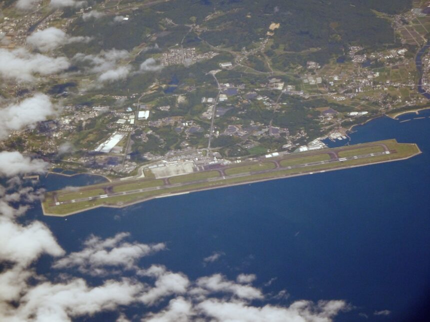
Featured image: Oita Airport aerial photograph by Bruno Plus via Wikimedia Commons, licensed under CC BY 4.0. Cropping or resizing may be applied for site display. Use here does not imply endorsement by the creator, Wikimedia, Oita Airport, any airport operator, airline, bus operator, taxi company, rental-car company, tourism organization, or public agency.
Sources
- MLIT: airport list
- Matsuyama Airport official site
- Toyama Airport facilities
- Komatsu Airport facilities
- Okayama Airport facilities
- Yonago Airport floor guide
- Hiroshima Airport 3F guide
- Izumo Airport deck
- Takamatsu Airport observation deck
- Kochi Ryoma Airport facilities
- Tokushima Airport 3F guide
- Kitakyushu Airport observation deck
- Oita Airport facilities
- Saga Airport space park
- Nagasaki Airport observation deck
- Kumamoto Airport observation space
- Miyazaki Airport observation deck
- Kagoshima Airport view deck
- Nanki Shirahama Airport official site
- Wikimedia Commons image page
Editorial disclosure: This is an independent travel-planning guide. It is not affiliated with MLIT, airport operators, airlines, ground-transport operators, local governments, tourism organizations, Wikimedia, or the image creator.