Short answer
Kikai Airport is a good small-island airport day for transport fans, but it is different from the island airports with official viewing decks. Kagoshima Prefecture’s services page lists no observation deck at Kikai Airport, so make the public terminal, the 1,200m runway context, Wan Port access, rental-car planning, local bus or taxi checks, and one gentle island branch the point of the trip.
Last checked: August 21, 2026. Flight operations, airline schedules, airport services, parking rules, rental-car inventory, bus timetables, taxi availability, ferry sailings, bicycle and motorcycle rental, beaches, cycling routes, weather, and typhoon disruption can change. Always confirm current details on official airport, airline, ferry, town, tourism, transport, and weather pages before travel.
Why Kikai works for aviation fans
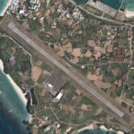
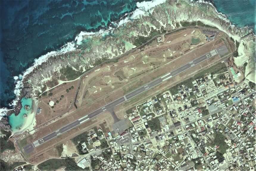
Kikai Airport sits on the west coast of Kikaijima, a small Amami Islands island east of Amami Oshima. Kagoshima Prefecture’s airport page describes Kikaijima as a raised coral-reef island and records the airport’s current runway as 1,200m x 30m, with one apron position for a propeller aircraft. That makes the airport a compact place to understand how island air service, short runways, ports, and local movement fit together.
The main caution is just as important: the official services page lists no observation deck. Treat Kikai as an airport-area study day, not a deck-based plane-spotting day. Stay inside public terminal areas, use legal roads and sidewalks, and avoid fence lines, service roads, private land, drone use, or anything that could interfere with airport operations or local traffic.
Start with the terminal facts
The services page gives a practical picture of a small island airport. It lists passenger and cargo facility hours by season, Wi-Fi, lockers in the airport lobby, wheelchair rental through the Amami Aviation Kikai Airport office, rental-car guidance in the first-floor lobby, and the first-floor Kikai Airport shop Masuda for food and retail. It also lists no fuel facility, no general information desk, no tourism information center, no lounge, no ATM, no baggage storage, and no observation deck.
Those details help set expectations. Bring enough cash, do not assume large-airport services, and check whether the specific service you need is available on your travel date. If you want to photograph aircraft, keep it simple and respectful: use public areas only and accept that this airport may be more about arrival, departure, and island logistics than long viewing sessions.
Use Wan Port and town access as the transport hook
The services page says Kikai Airport is about 5 minutes by car from Wan Port and about 5 minutes by car from Kikai Town Hall. That is the strongest transport hook for a first plan. You can compare air arrival, port movement, town services, and onward island travel without building an overloaded day.
Kikai Town’s access page lists air access from Kagoshima and Amami Oshima, and it also records ferry service as a major sea route. The same page warns that ferry dates, vessels, and ports of call can change and should be confirmed with the company or agent. Use that warning as your planning rule: flights, ferries, bus schedules, and rental vehicles all need current checks, especially during bad weather or typhoon season.
Prearrange island movement
Kikai Town’s on-island transport page lists a local bus office, taxi, community transport, rental-car providers, and substitute-driver contact information. Discover Kagoshima’s traveler information also gives basic bus-use guidance and lists bicycle and motorcycle rental information. For visitors, the practical lesson is clear: decide your movement method before you land.
A rental car can make the most sense if you want to connect the airport, Wan Port, viewpoints, villages, beaches, and food stops. A bus or bicycle-based plan can work if you design it around current timetables, daylight, heat, and distance. A taxi plan should be arranged with realistic dispatch time and return movement in mind.
Choose one island branch
Discover Kagoshima describes Kikaijima as an elevated coral-reef island with villages, coral stone walls, beaches, lagoons, butterflies, sugar cane, white sesame, cycling, Sugar Road, and the Hyakunodai viewpoint. These are good add-ons, but they should not compete with your flight or ferry window.
For a first airport-area day, choose one branch. A transport-focused branch can connect the airport with Wan Port and the town center. A scenery branch can use a rental car or bicycle route toward coral-stone village scenery, Sugar Road, or Hyakunodai. A beach branch should stay weather-aware and modest, especially when heat, wind, tides, or return transport are uncertain.
Simple first-time plan
| Step | What to do | Why it works |
|---|---|---|
| 1 | Check flight status, JAC schedule, terminal services, parking hours, ferry status, bus timetable, rental-car availability, taxi options, and weather | Kikai plans depend on small-island transport and weather |
| 2 | Use the public terminal and airport facts as the aviation anchor | The official service page lists no observation deck |
| 3 | Connect the airport with Wan Port or Kikai Town Hall area by prearranged car, taxi, bus, or pickup | The airport is close to the port and town by car |
| 4 | Add one island branch: port logistics, town food, coral-stone village scenery, Sugar Road, Hyakunodai, cycling, or a beach stop | One branch protects your return window |
| 5 | Leave buffers before flights, ferries, rental returns, bus departures, and sunset | Remote-island transport rewards extra time |
Where this fits in the transport hub
Use this as the Kikai branch of the Japan Transport Fan Travel Guide. It pairs naturally with Amami, Tokunoshima, Okinoerabu, Yoron, and other Amami Islands airport-area guides, but Kikai stands out because it is a no-observation-deck airport where the strongest story is the connection between a short runway, a nearby port, local transport, and a raised coral island landscape.
Photo credit
Featured image: Kikai Airport Aerial photograph.2013, by Geospatial Information Authority of Japan, made based on National Land Image Information (Color Aerial Photographs), Ministry of Land, Infrastructure, Transport and Tourism, via Wikimedia Commons. MLIT National Land Image Information permission allows use for any purpose with proper attribution. Cropping or resizing may be applied for site display. The image is used in editorial transport-travel-guide context and does not imply endorsement by MLIT, GSI, Kagoshima Prefecture, Kikai Airport, airport operators, airlines, ferry operators, tourism organizations, Wikimedia, or the uploader.
Sources
- Kagoshima Prefecture: Kikai Airport
- Kagoshima Prefecture: operating rules for Kikai Airport
- Kagoshima Prefecture: services provided by Kikai Airport
- Kikai Town: access to the town
- Kikai Town: on-island transport
- Kikaijima Geopark: access
- Discover Kagoshima: getting around Kagoshima
- Discover Kagoshima: Kikaijima’s World
- Discover Kagoshima: Kikaijima traveler information
- Wikimedia Commons image file and license record
Editorial disclosure: This is an independent planning guide. It is not affiliated with Kagoshima Prefecture, Kikai Town, MLIT, GSI, Kikai Airport, Japan Air Commuter, JAL, ferry operators, bus operators, taxi operators, rental-car companies, Discover Kagoshima, Kikaijima Geopark, tourism organizations, Wikimedia, or the image uploader.