Make the volcano the plan, not a rushed add-on
Short answer: Mt. Mihara and Ura-Sabaku are the strongest landscape reasons to visit Izu Oshima, but they need a real plan. Check ferry or flight operation status, Oshima Bus timing, weather, and official volcano information before going. Then choose either a focused Mt. Mihara walk, a Ura-Sabaku-focused route, or a shorter weather-safe backup.
Last checked: August 27, 2026. Volcano information, weather, trails, buses, ferry operations, facilities, access routes, and safety restrictions can change. Confirm current information with Izu Oshima Geopark, JMA, Oshima Bus, Tokai Kisen, and local official sources before travel.
What Mt. Mihara is
Izu Oshima Geopark describes Mt. Mihara as a central cone formed in the summit caldera of Izu Oshima Volcano. Its official English page says the cone is about 150 m high, about 800 m in diameter at the summit, and about 1,200 m in diameter at the base. The same page explains that black streaks on the slopes are remains of lava flows from the 1986 eruption.
This is why the mountain feels different from a normal viewpoint walk. You are reading a living volcanic landscape, not only climbing for a view. JNTO also highlights Mt. Mihara as one of the main reasons to visit Izu Oshima, alongside hiking trails, cycling, beaches, swimming, and diving.
What Ura-Sabaku is
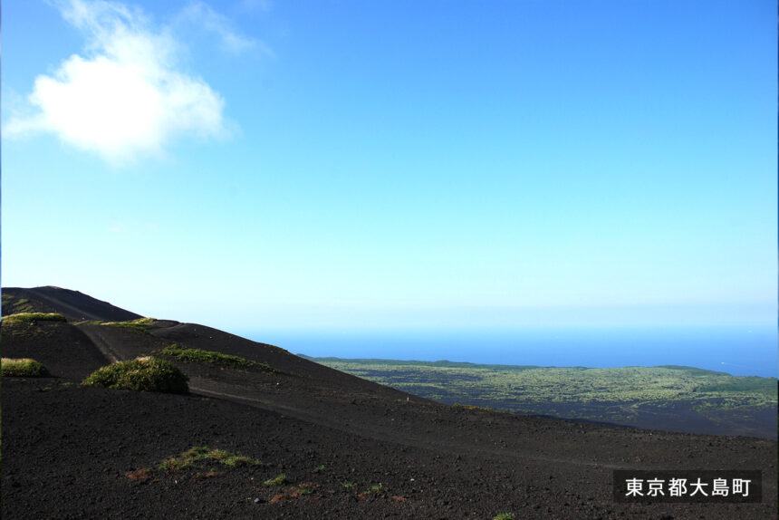
Izu Oshima Geopark describes Ura-Sabaku as an area of volcanic ash and scoria on the northeast side of Mt. Mihara. The page explains that wind, eruption deposits, rainwater movement, and difficult vegetation establishment help preserve its black desert-like scenery. That is the travel appeal: it looks spare and dramatic because the ground is still telling the volcano story.
Ura-Sabaku is not a casual beach or city park. Wind, fog, rain, heat, loose ground, and route uncertainty can make the experience harder than the photos suggest. If you are new to the island, consider a guided plan or a conservative route.
Choose one route shape
| Route shape | Best for | Main caution |
|---|---|---|
| Mt. Mihara first | Travelers who want the classic volcano view and a straightforward main objective. | Check JMA and Geopark information, weather, footwear, and return transport. |
| Ura-Sabaku focus | Repeat visitors, strong walkers, and people who specifically want the black scoria landscape. | Do not underestimate wind, exposure, route finding, or return timing. |
| Short volcano taste | First-time visitors with limited time or uncertain weather. | Stop before the plan becomes dependent on the last bus or perfect visibility. |
| Guided volcano day | Travelers who want geological explanation and less uncertainty. | Book with a current local operator and confirm language, route, weather policy, and pickup. |
| Weather backup | Families, tired travelers, and anyone with a fixed return ferry. | Switch early to onsen, port town, museum, or short coast time when conditions are poor. |
What to check before walking
The Izu Oshima Geopark volcano information page tells tourists climbing Mt. Mihara to check JMA volcanic information before climbing, and says the hiking paths have some areas with poor footholds. It recommends mountain boots or hiking shoes. Treat that as the minimum baseline, not expert hiking advice.
Use JMA for official volcanic warnings and weather warnings, Izu Oshima Geopark for volcano and geosite context, Oshima Bus for current route timing, and Tokai Kisen for same-day ferry operation status. If any one of those checks is weak, make the day smaller.
No-car planning
Mt. Mihara can fit a no-car Oshima trip when bus timing, weather, and return planning line up. Oshima Bus publishes current route bus timetables and island-map materials. Check the exact current timetable for your travel date, because island bus schedules are not something to improvise from memory.
If you are also trying to see Habu Port, Oshima Park, a coast walk, and an onsen on the same day, the bus plan may become too brittle. For a first no-car trip, make the volcano the main event and keep the backup simple.
Responsible volcano travel
- Check official volcano information before entering the mountain area.
- Wear footwear suitable for uneven volcanic paths.
- Carry water, sun protection, rain protection, and a charged phone.
- Turn around early if fog, wind, heat, rain, or time pressure makes the route feel uncertain.
- Do not enter restricted areas, unstable slopes, or places marked off by official guidance.
- Keep the return ferry, bus, or taxi plan separate from the hike itself.
Related Oshima guides
- Izu Oshima Travel Guide for First-Time Visitors
- Izu Oshima by Bus Guide
- Izu Oshima Ferry Disruption and Rebooking Guide
Photo credit
Featured image: Ura-Sabaku volcanic scoria landscape, from Izu Oshima Photo Studio, operated by Tokyo Oshima Town. The image is used under the site’s published terms, which allow edited commercial website use subject to restrictions. Cropping or resizing may be applied for site display. Use here does not imply endorsement by Tokyo Oshima Town, Izu Oshima Photo Studio, Izu Oshima Geopark, JMA, Oshima Bus, Tokai Kisen, or any operator.
Sources
- Izu Oshima Geopark: Mt. Mihara
- Izu Oshima Geopark: Ura-Sabaku Desert
- Izu Oshima Geopark: volcano information
- JNTO: Izu Oshima Island
- JMA: Izu-Oshima volcano profile
- JMA: volcanic warnings and alert levels
- JMA multilingual weather warnings
- Oshima Bus route bus page
- Tokai Kisen operation status
- Izu Oshima Photo Studio image page and terms
Editorial disclosure: This is an independent travel-planning guide. It is not affiliated with Izu Oshima Geopark, JMA, JNTO, Tokyo Oshima Town, Izu Oshima Photo Studio, Oshima Bus, Tokai Kisen, or any tourism operator.