Use the south coast as one route, not scattered bus stops
Short answer: Habu Port and the south coast are best planned as one Izu Oshima route. Combine Habu Port, the Great Road Cut, Fudeshima, Toshiki Coast, and one backup stop only if current bus timing, weather, and return transport make sense. This is a geologic coast, not a checklist.
Last checked: August 27, 2026. Bus timetables, ferry ports, taxis, rental vehicles, weather, cliff conditions, facility access, and safety restrictions can change. Confirm current details with Izu Oshima Geopark, Oshima Bus, Oshima Tourism Association, Tokai Kisen, and local official sources before travel.
Why Habu Port matters
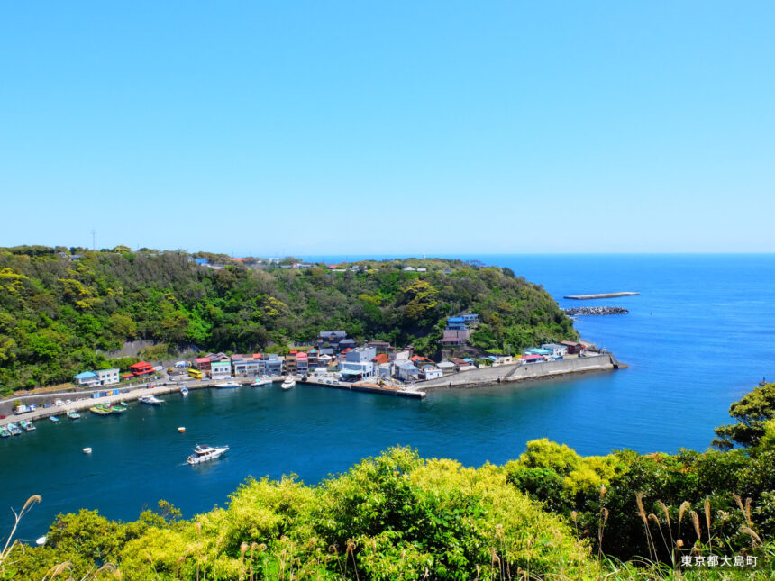
Izu Oshima Geopark describes Habu Port as an explosion-crater landscape. Its official English page says a volcanic crater formed in the early 9th century and became a lake. In 1703, the Genroku earthquake caused a tsunami that broke the lake edge and connected it to the sea. People removed remaining large rocks and opened Habu Port in 1800.
The same Geopark page explains that surrounding cliffs protected the port from strong winds, helping it flourish until the mid-1900s, and that its beauty attracted poets and artists. That makes Habu more than a destination name. It is a port town where geology, sea access, and culture overlap.
The south-coast geosites
| Place | Why it matters | Planning note |
|---|---|---|
| Habu Port | An explosion-crater port shaped by eruption, lake formation, tsunami opening, and later port-town history. | Use as the route anchor, not only a quick photo stop. |
| The Great Road Cut | Izu Oshima Geopark says more than 100 large eruptions over 18,000 years created the layered structure. | Stay outside guardrails; the official page warns of cliff-collapse risk. |
| Fudeshima | A remnant of an extinct volcano, with dykes showing magma that rose through underground cracks and solidified. | Best treated as a viewpoint and geology stop, not a place to scramble around. |
| Toshiki Coast | A lava and cliff landscape with 40 m sea cliffs, bomb sag features, and eroding cliffs. | Be conservative around waves, wind, rocks, and cliff edges. |
| West and south road views | JNTO points travelers to the southwest road between Motomachi Port and Habu Port for the strata section. | Works better with a rental car, taxi plan, or carefully checked bus timing. |
Bus, car, or taxi?
A bus-based south-coast plan can work, but it needs a simple route. Oshima Bus publishes current route bus timetable and island-map materials. Check the current timetable before choosing stops, because a route that looks close on a map may not fit the return bus.
A rental car gives the most freedom for Habu Port, viewpoints, coast stops, and slow photography. A taxi can be useful for targeted movement, but the Oshima Tourism Association says taxis do not cruise around the island, night service is mostly not operating, most taxis wait at ports or the airport, and travelers should call by phone. If a taxi matters, call ahead.
A practical half-day shape
For a first south-coast route, start with the access decision. If arriving by ferry, confirm whether the active port is Okada or Motomachi. If using the bus, check the Habu direction timetable and the return before committing to the first stop. If using a rental car, confirm pickup and return around the port of the day.
Then choose a main pair: Habu Port plus the Great Road Cut, or Habu Port plus Fudeshima or Toshiki Coast. Add more only if time, weather, and return transport are still easy. The south coast rewards slower looking; it does not need to be rushed.
Safety and manners
- Stay outside guardrails at the Great Road Cut.
- Do not climb unstable cliffs or volcanic rock for photos.
- Watch waves, wind, wet rock, and erosion at coastal sites.
- Keep roads, bus stops, and local work areas clear.
- Carry water and sun protection; shade can be limited.
- Check return transport before walking away from the bus route.
Related Oshima guides
- Izu Oshima Travel Guide for First-Time Visitors
- Izu Oshima by Bus Guide
- Mount Mihara and Ura-Sabaku Guide
- Izu Oshima Ports and Transfers Guide
Photo credit
Featured image: Habu Port and port town, from Izu Oshima Photo Studio, operated by Tokyo Oshima Town. The image is used under the site’s published terms, which allow edited commercial website use subject to restrictions. Cropping or resizing may be applied for site display. Use here does not imply endorsement by Tokyo Oshima Town, Izu Oshima Photo Studio, Izu Oshima Geopark, Oshima Bus, Oshima Tourism Association, Tokai Kisen, taxi companies, or rental providers.
Sources
- Izu Oshima Geopark: Habu Port
- Izu Oshima Geopark: The Great Road Cut
- Izu Oshima Geopark: Fudeshima / Fudeshima Coast
- Izu Oshima Geopark: Toshiki Coast
- JNTO: Izu Oshima Island
- Oshima Tourism Association transport page
- Oshima Bus route bus page
- Izu Oshima Photo Studio image page and terms
Editorial disclosure: This is an independent travel-planning guide. It is not affiliated with Izu Oshima Geopark, JNTO, Oshima Tourism Association, Oshima Bus, Tokyo Oshima Town, Izu Oshima Photo Studio, Tokai Kisen, taxi companies, rental providers, or tourism operators.